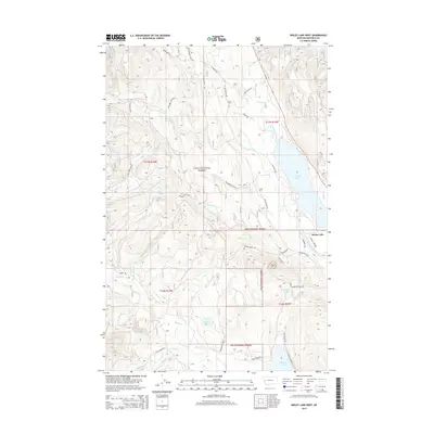
2014 Map of Seeley Lake West
USGS Topo · Published 2014About this map
Seeley Lake and the surrounding wilderness of the Lolo National Forest dominate this landscape in Missoula County. The settlement at the northern edge of the lake serves as a focal point for a region defined by its complex hydrology, where the Clearwater River feeds through a chain of lakes including Placid Lake and the smaller Tupper Lake. The terrain is marked by an extensive network of forest roads and trails, such as Archibald Cr Loop and Boy Scout Rd, which provide access to more remote water bodies like Hidden Lake. Drainage patterns from Placid Cr and Finley Cr illustrate the watershed of the Lolo National Forest, while specific family-named landmarks like Cahoon Ranch Rd offer clues to the historical land use and early ranching boundaries that persist within the federal forest lands.
Find a feature on this map
40 named features on this map. Tap any name to fly to it.
Don’t see what you’re looking for? This feature index may not catch every label — zoom into the map to look around manually.
Map Details
Editions of this 2014 Seeley Lake West Map
This is the sole edition of this map. No revisions or reprints were ever made.
Other maps of this area

1902 · Ovando
USGS Topo · 1:125,000

1905 · Ovando
USGS Topo · 1:125,000

1921 · Elbow Lake
USGS Topo · 1:125,000

1955 · Choteau
USGS Topo · 1:250,000

1957 · Choteau
USGS Topo · 1:250,000

1958 · Choteau
USGS Topo · 1:250,000

1962 · Choteau
USGS Topo · 1:250,000

1965 · Upper Jocko Lake
USGS Topo · 1:24,000
1965 · Gold Creek Peak
USGS Topo · 1:24,000

1965 · Seeley Lake West
USGS Topo · 1:24,000