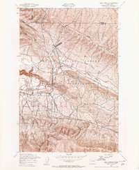
1953 Map of Selah Springs
USGS Topo · Published 1957About this map
The Yakima Firing Center Military Reservation dominates this mid-century landscape, illustrating the heavy military footprint in the region shortly after the Second World War. This specialized terrain is characterized by various aviation and defense installations, including a Drone Landing Strip, a Drone Take-off Strip, and an Asphalt Strip. The infrastructure recorded here reveals a shift in land use, where an Abandoned Irrigation Ditch and an Abandoned Dam suggest a transition away from earlier agricultural or water-management efforts toward military training operations.
Find a feature on this map
19 named features on this map. Tap any name to fly to it.
Don’t see what you’re looking for? This feature index may not catch every label — zoom into the map to look around manually.
Map Details
Editions of this 1953 Selah Springs Map
Other maps of this area

1936 · Yakima East
USGS Topo · 1:48,000

1936 · Hog Ranch Buttes
USGS Topo · 1:48,000

1938 · Badger Pocket
USGS Topo · 1:48,000

1939 · Boylston
USGS Topo · 1:48,000

1941 · Black Rock Spring
USGS Topo · 1:62,500

1941 · Yakima East
USGS Topo · 1:62,500

1943 · Boylston
USGS Topo · 1:62,500

1943 · Badger Pocket
USGS Topo · 1:62,500

1950 · Yakima
USGS Topo · 1:250,000

1953 · McDonald Spring
USGS Topo · 1:24,000