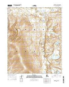
2015 Map of Selawik B-3 SE
USGS Topo · Published 2015About this map
The Mangoak River winds through this expanse of the Northwest Arctic, carving a path through terrain defined by intricate elevation changes and numerous small water bodies. This 2015 survey reveals a landscape of high-latitude wetlands and ridges, where the river serves as the primary named geographic corridor. The topography is marked by significant landforms in the western sections, with elevations reaching above 800 feet, contrasting sharply with the lower, pond-filled basins to the east. Public Land Survey System grids, including t11n r7w, t11n r6w, t10n r7w, and t10n r6w, provide the administrative framework for this remote Arctic environment.
Find a feature on this map
5 named features on this map. Tap any name to fly to it.
Don’t see what you’re looking for? This feature index may not catch every label — zoom into the map to look around manually.
Map Details
Editions of this 2015 Selawik B-3 SE Map
This is the sole edition of this map. No revisions or reprints were ever made.
Other maps of this area

1951 · Selawik
USGS Topo · 1:250,000

1955 · Selawik B-3
USGS Topo · 1:63,360

1955 · Selawik A-3
USGS Topo · 1:63,360

1957 · Selawik
USGS Topo · 1:250,000
1985 · Selawik A-2
USGS Topo · 1:63,360
1985 · Selawik B-2
USGS Topo · 1:63,360
2014 · Selawik A-3 NW
USGS Topo · 1:25,000
2014 · Selawik A-2 NW
USGS Topo · 1:25,000
2014 · Selawik B-3 SW
USGS Topo · 1:25,000
2015 · Selawik B-2 SW
USGS Topo · 1:25,000