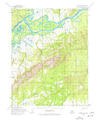
1955 Map of Selawik D-3
USGS Topo · Published 1977About this map
Kiana serves as a vital focal point where the Squirrel River meets the braided channels of the Kobuk River. This mid-century survey illustrates the importance of seasonal transport in the Arctic, documenting the Winter Trail and Winter Portage Trail that connect the river systems across the landscape. The infrastructure of the era is anchored by the Bob Baker Memorial Airport and the adjacent Bob Baker Memorial Airport Cem, reflecting the region's reliance on aviation for year-round access. To the south, the Hockley Hills dominate the interior, punctuated by remote outposts like the Singauruk Shelter Cabin along the Singauruk River. The map details a network of drainage systems, including Napaktuk Creek and Ohtaron Creek, which define the low-lying tundra and wetland areas between the high ridges and the river banks.
Find a feature on this map
15 named features on this map. Tap any name to fly to it.
Don’t see what you’re looking for? This feature index may not catch every label — zoom into the map to look around manually.
Map Details
Editions of this 1955 Selawik D-3 Map
2 editions found
Other maps of this area

1951 · Baird Mountains
USGS Topo · 1:250,000

1951 · Selawik
USGS Topo · 1:250,000

1955 · Selawik D-2
USGS Topo · 1:63,360

1955 · Baird Mountains A-2
USGS Topo · 1:63,360

1955 · Selawik D-4
USGS Topo · 1:63,360

1955 · Selawik C-3
USGS Topo · 1:63,360

1955 · Selawik D-3
USGS Topo · 1:63,360

1955 · Selawik C-4
USGS Topo · 1:63,360

1955 · Baird Mountains A-3
USGS Topo · 1:63,360

1955 · Baird Mountains A-4
USGS Topo · 1:63,360