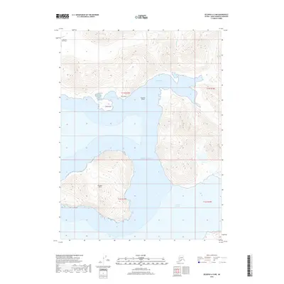
2018 Map of Seldovia A-5 NW
USGS Topo · Published 2018About this map
Elizabeth Island and the southwestern reaches of the Kenai Peninsula dominate this maritime landscape where the Pacific Ocean meets the complex inlets of the Alaska coast. The map details a rugged coastal geography defined by deep-water harbors like Port Chatham and the narrow Chugach Passage, which separates the large island from the mainland. Shoreline features such as Claim Point, Kelp Point, and Chrome Bay suggest a history of maritime navigation and resource proximity in this isolated region. Inland, the English Bay River drains the northern high ground, while the Dog Fish Bay Airport provides a critical aviation link for this roadless territory. The terrain is marked by steep elevation changes, with the coastal hills rising sharply from the sea, illustrating the topographical challenges of the Kenai Peninsula's tip.
Find a feature on this map
14 named features on this map. Tap any name to fly to it.
Don’t see what you’re looking for? This feature index may not catch every label — zoom into the map to look around manually.
Map Details
Editions of this 2018 Seldovia A-5 NW Map
This is the sole edition of this map. No revisions or reprints were ever made.
Other maps of this area

1951 · Seldovia
USGS Topo · 1:250,000

1951 · Seldovia B-5
USGS Topo · 1:63,360

1951 · Seldovia A-6
USGS Topo · 1:63,360

1951 · Seldovia B-6
USGS Topo · 1:63,360

1952 · Seldovia A-6
USGS Topo · 1:63,360

1953 · Seldovia B-6
USGS Topo · 1:63,360

1953 · Seldovia A-5
USGS Topo · 1:63,360

1953 · Seldovia B-5
USGS Topo · 1:63,360

1963 · Seldovia
USGS Topo · 1:250,000
1987 · Seldovia B-5 SW
USGS Topo · 1:25,000