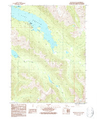
1987 Map of Seldovia B-5 SW
USGS Topo · Published 1987About this map
Port Graham serves as the primary coastal anchor on this coastal portion of the Kenai Peninsula, situated along the deep waters of the Port Graham inlet. The landscape is defined by the heavy influence of tidal waterways, including Johnson Slough, Ducan Slough, and Tulcan Slough, which weave through the low-lying coastal terrain. These sloughs suggest a dynamic maritime environment where seasonal changes and tides dictate the movement of people and resources near the shoreline. Farther inland, the topography rises toward distinct peaks and ridges with names like Ivory, Osage, and Jewel. The English Bay River meanders through the southern half of the quadrangle, illustrating the drainage patterns from the inland heights down to the coastal bays. This 1980s-era data reflects the established settlements and natural geography prior to modern environmental shifts on the peninsula.
Find a feature on this map
13 named features on this map. Tap any name to fly to it.
Don’t see what you’re looking for? This feature index may not catch every label — zoom into the map to look around manually.
Map Details
Editions of this 1987 Seldovia B-5 SW Map
This is the sole edition of this map. No revisions or reprints were ever made.
Other maps of this area

1951 · Seldovia
USGS Topo · 1:250,000

1951 · Seldovia B-5
USGS Topo · 1:63,360

1951 · Seldovia A-6
USGS Topo · 1:63,360

1951 · Seldovia B-6
USGS Topo · 1:63,360

1952 · Seldovia A-6
USGS Topo · 1:63,360

1953 · Seldovia B-6
USGS Topo · 1:63,360

1953 · Seldovia A-5
USGS Topo · 1:63,360

1953 · Seldovia B-5
USGS Topo · 1:63,360

1963 · Seldovia
USGS Topo · 1:250,000
1987 · Seldovia B-6 NE
USGS Topo · 1:25,000