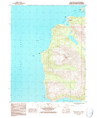
1987 Map of Seldovia B-6 SE
USGS Topo · Published 1987About this map
English Bay sits at the northern edge of this coastal peninsula, serving as a primary point of settlement where the shoreline meets the South Channel. The landscape is dominated by the steep ascent of Mount Bede, which anchors the interior terrain between the waters of Cook Inlet to the west and the sheltered reaches of Port Graham to the northeast. Near the village, a small Landing Strip provides a critical transportation link for this maritime community, while Russian Point marks the entrance to the bay.
Find a feature on this map
18 named features on this map. Tap any name to fly to it.
Don’t see what you’re looking for? This feature index may not catch every label — zoom into the map to look around manually.
Map Details
Editions of this 1987 Seldovia B-6 SE Map
This is the sole edition of this map. No revisions or reprints were ever made.
Other maps of this area

1951 · Seldovia
USGS Topo · 1:250,000

1951 · Seldovia B-5
USGS Topo · 1:63,360

1951 · Seldovia A-6
USGS Topo · 1:63,360

1951 · Seldovia B-6
USGS Topo · 1:63,360

1952 · Seldovia A-6
USGS Topo · 1:63,360

1953 · Seldovia B-6
USGS Topo · 1:63,360

1953 · Seldovia A-5
USGS Topo · 1:63,360

1953 · Seldovia B-5
USGS Topo · 1:63,360

1963 · Seldovia
USGS Topo · 1:250,000
1987 · Seldovia B-6 NE
USGS Topo · 1:25,000