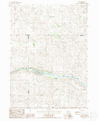
1987 Map of Seneca
USGS Topo · Published 1988About this map
The Middle Loup River winds through the heart of this landscape, providing the lifeblood for a series of established cattle operations and the small settlement of Seneca. This mid-1980s landscape is defined by its wide-ranging ranches, including Van Dusen Ranch, Edelman Ranch, and Walker Ranch, which occupy the undulating terrain surrounding the river valley. The map documents the boundary where Cherry Co and Hooker Co meet Thomas Co, illustrating the social and economic reach of the local ranching families across county lines.
Find a feature on this map
14 named features on this map. Tap any name to fly to it.
Don’t see what you’re looking for? This feature index may not catch every label — zoom into the map to look around manually.
Map Details
Editions of this 1987 Seneca Map
This is the sole edition of this map. No revisions or reprints were ever made.
Other maps of this area

1948 · Seneca
USGS Topo · 1:62,500

1948 · Thedford
USGS Topo · 1:62,500

1948 · Seneca 4
USGS Topo · 1:62,500

1949 · Seneca 4
USGS Topo · 1:62,500

1950 · Thedford
USGS Topo · 1:62,500

1950 · Shimmins Lake
USGS Topo · 1:62,500

1951 · Seneca
USGS Topo · 1:62,500

1954 · North Platte
USGS Topo · 1:250,000

1956 · North Platte
USGS Topo · 1:250,000

1957 · North Platte
USGS Topo · 1:250,000