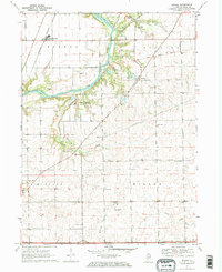
1970 Map of Serena
USGS Topo · Published 1972About this map
The Fox River carves a winding path through this portion of LaSalle County, where the Old Indian Treaty Boundary still marks the landscape north of Norway. This 1970 snapshot of the Illinois countryside shows a region defined by its watercourses and early pioneer legacies, including numerous family and community burial grounds such as Nelson Cem and Spradling Cem. The village of Serena sits in the northwest, served by the Burlington Northern railroad, while the eastern reaches are dotted with local institutions like Norway Ch and Pope Sch.
Find a feature on this map
39 named features on this map. Tap any name to fly to it.
Don’t see what you’re looking for? This feature index may not catch every label — zoom into the map to look around manually.
Map Details
Editions of this 1970 Serena Map
2 editions found
Other maps of this area

1892 · Marseilles
USGS Topo · 1:62,500

1892 · Ottawa
USGS Topo · 1:62,500

1915 · Ottawa
USGS Topo · 1:62,500

1916 · Marseilles
USGS Topo · 1:62,500

1940 · Marseilles
USGS Topo · 1:62,500

1946 · Ottawa
USGS Topo · 1:62,500

1948 · Sandwich
USGS Topo · 1:62,500

1950 · Sandwich
USGS Topo · 1:62,500

1951 · Earlville
USGS Topo · 1:62,500

1958 · Aurora
USGS Topo · 1:250,000