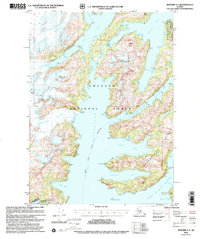
2000 Map of Seward A-4
USGS Topo · Published 2002About this map
Chenega Glacier and Tigertail Glacier dominate the northwestern reaches of this maritime landscape, where ice flows meet the deep waters of Icy Bay. The region is defined by complex coastal waterways, including the deep Bainbridge Passage and the seasonal navigation path of the Alaska Marine Highway (Summer Route) which cuts through Port Bainbridge. Topography here ranges from sea-level fiords to the 3,365-foot peak of Claw Peak, with much of the land protected within the Chugach National Forest. While largely uninhabited, signs of resource extraction appear near Eleshansky Cove where a Mine is noted, and the southern edge includes a portion of the Alaska Maritime National Wildlife Reserve. The interplay of active glaciers and protected islands like Bainbridge Island illustrates a wilderness undergoing continuous geological change.
Find a feature on this map
32 named features on this map. Tap any name to fly to it.
Don’t see what you’re looking for? This feature index may not catch every label — zoom into the map to look around manually.
Map Details
Editions of this 2000 Seward A-4 Map
This is the sole edition of this map. No revisions or reprints were ever made.
Other maps of this area

1946 · Blying Sound
USGS Topo · 1:250,000

1950 · Seward B-3
USGS Topo · 1:63,360

1950 · Blying Sound D-4
USGS Topo · 1:63,360

1950 · Blying Sound D-5
USGS Topo · 1:63,360

1951 · Blying Sound
USGS Topo · 1:250,000

1951 · Seward
USGS Topo · 1:250,000

1951 · Seward B-4
USGS Topo · 1:63,360

1951 · Seward A-5
USGS Topo · 1:63,360

1951 · Seward A-3
USGS Topo · 1:63,360

1951 · Seward B-5
USGS Topo · 1:63,360