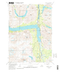
1951 Map of Seward B-7
USGS Topo · Published 1986About this map
Moose Pass and the tight corridor of the Alaska Railroad anchor this 1951 study of the Kenai Peninsula’s interior. The map documents a landscape defined by high-altitude mining and early transportation routes through the Chugach National Forest. Industrial sites such as the Crown Point Mine, Falls Creek Mine, and Primrose Mine are scattered across the slopes of Madson Mountain and Solars Mountain, indicating the era’s active mineral extraction. Along the shores of Kenai Lake and Upper Trail Lake, small settlements like Lawing and Lakeview appear alongside essential infrastructure, including a Landing Strip and the Seward Anchorage Highway. Glacial waters from Snow River and numerous lakes like Grant Lake and Lost Lake dominate the lowlands, reflecting a complex drainage system that supported both the local railway and the Solars Sawmill.
Find a feature on this map
62 named features on this map. Tap any name to fly to it.
Don’t see what you’re looking for? This feature index may not catch every label — zoom into the map to look around manually.
Map Details
Editions of this 1951 Seward B-7 Map
4 editions found
Other maps of this area

1950 · Seward A-6
USGS Topo · 1:63,360

1950 · Seward A-8
USGS Topo · 1:63,360

1950 · Seward A-7
USGS Topo · 1:63,360

1951 · Seward
USGS Topo · 1:250,000

1951 · Seward A-6
USGS Topo · 1:63,360

1951 · Seward A-7
USGS Topo · 1:63,360

1951 · Seward B-7
USGS Topo · 1:63,360

1951 · Seward C-6
USGS Topo · 1:63,360

1951 · Seward B-6
USGS Topo · 1:63,360

1951 · Seward C-8
USGS Topo · 1:63,360