
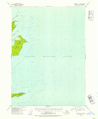
1952 Map of Seward C-1
USGS Topo · Published 1954About this map
Prince William Sound dominates this mid-century maritime survey, focusing on the remote archipelago within the Chugach National Forest. The map documents the intricate coastline and bathymetry surrounding Naked Island, Peak Island, and Smith Island, providing soundings in feet and detailed topographic relief of the landforms. On the southern edge of the sheet, the presence of Cabins on Smith Island suggests seasonal habitation or maritime shelter, while the designated Lighthouse Reserve at the island's eastern end points to the critical importance of navigational aids in these northern waters. Narrow waterways like Liljegren Passage and McPherson Passage separate the islands, which feature numerous named coastal points such as Elk Head Point and East Point. This document serves as a precise record of the shoreline and maritime infrastructure before more modern developments, showing the sound as it functioned for mariners in the early 1950s.
Find a feature on this map
19 named features on this map. Tap any name to fly to it.
Don’t see what you’re looking for? This feature index may not catch every label — zoom into the map to look around manually.
Map Details
Editions of this 1952 Seward C-1 Map
2 editions found
Other maps of this area

1948 · Cordova
USGS Topo · 1:250,000

1950 · Cordova C-8
USGS Topo · 1:63,360

1951 · Seward
USGS Topo · 1:250,000

1951 · Cordova
USGS Topo · 1:250,000

1951 · Seward B-1
USGS Topo · 1:63,360

1951 · Seward D-2
USGS Topo · 1:63,360

1951 · Seward D-1
USGS Topo · 1:63,360

1951 · Seward B-2
USGS Topo · 1:63,360

1951 · Cordova D-8
USGS Topo · 1:63,360

1951 · Seward C-1
USGS Topo · 1:63,360