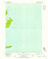
1952 Map of Seward C-1
USGS Topo · Published 1954About this map
Naked Island dominates this maritime survey of the central Prince William Sound, where the terrain rises sharply from the deep glacial waters of the Chugach National Forest. The geography is defined by a series of passages and bays, including McPherson Passage and McPherson Bay, which separate the larger island from its northern neighbor, Peak Island. To the south, Smith Island provides a rare point of human interest on this 1952 chart, featuring a small cluster of Cabins and a designated Lighthouse Reserve on its eastern tip near Henry. These few labels suggest the early infrastructure for navigation and seasonal residence in an area primarily used for fishing and maritime transit. The detailed bathymetry throughout the sound highlights the extreme depths and underwater contours surrounding landmarks like East Point and Elk Head Point.
Find a feature on this map
19 named features on this map. Tap any name to fly to it.
Don’t see what you’re looking for? This feature index may not catch every label — zoom into the map to look around manually.
Map Details
Editions of this 1952 Seward C-1 Map
2 editions found

Other maps of this area

1948 · Cordova
USGS Topo · 1:250,000

1950 · Cordova C-8
USGS Topo · 1:63,360

1951 · Seward
USGS Topo · 1:250,000

1951 · Cordova
USGS Topo · 1:250,000

1951 · Seward B-1
USGS Topo · 1:63,360

1951 · Seward D-2
USGS Topo · 1:63,360

1951 · Seward D-1
USGS Topo · 1:63,360

1951 · Seward B-2
USGS Topo · 1:63,360

1951 · Cordova D-8
USGS Topo · 1:63,360

1951 · Seward C-1
USGS Topo · 1:63,360