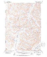
1952 Map of Seward C-8
USGS Topo · Published 1954About this map
Chugach National Forest encompasses this wilderness area on the Kenai Peninsula, where a complex network of glacial-fed drainages defines the geography. High peaks of the Kenai Mountains, including Gilpatrick Mountain and Round Mountain, rise above deeply cut valleys where trails and early roads were first established. The Sterling Highway makes a notable appearance in the southeastern corner near Quartz Creek, marking the post-war expansion of infrastructure into the Alaskan interior.
Find a feature on this map
37 named features on this map. Tap any name to fly to it.
Don’t see what you’re looking for? This feature index may not catch every label — zoom into the map to look around manually.
Map Details
Editions of this 1952 Seward C-8 Map
2 editions found

Other maps of this area

1944 · Kenai
USGS Topo · 1:250,000

1950 · Kenai
USGS Topo · 1:250,000

1950 · Kenai B-1
USGS Topo · 1:63,360

1951 · Seward
USGS Topo · 1:250,000

1951 · Kenai C-1
USGS Topo · 1:63,360

1951 · Seward B-7
USGS Topo · 1:63,360

1951 · Kenai D-1
USGS Topo · 1:63,360

1951 · Seward C-8
USGS Topo · 1:63,360

1951 · Seward D-8
USGS Topo · 1:63,360

1951 · Seward D-7
USGS Topo · 1:63,360