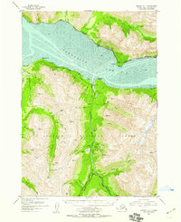
1952 Map of Seward D-7
USGS Topo · Published 1958About this map
Turnagain Arm dominates the northern horizon of this mid-century survey, its expansive mud flats revealing the dramatic tidal nature of the Alaskan coast. This area within the Chugach National Forest was a focal point for early mining activity, evidenced by the concentration of family-named operations like the Swetmann Mine, Hirshey Mine, and Connolly Mine. The settlement of Sunrise and the nearby Swetmann Camp reflect the rugged industry of the Kenai Peninsula, where the Palmer Creek Road and Hope Highway provided critical access to remote claims. Along the northern shore, the Alaska Railroad clings to the narrow strip of land between the mountains and the sea, passing through Indian and past Windy Point. The presence of the Sunrise Cemetery and Hope Cem provides essential grounding for genealogists tracing the lives of those who worked these steep creek valleys, including Sixmile Creek and Palmer Creek.
Find a feature on this map
64 named features on this map. Tap any name to fly to it.
Don’t see what you’re looking for? This feature index may not catch every label — zoom into the map to look around manually.
Map Details
Editions of this 1952 Seward D-7 Map
3 editions found

Other maps of this area

1951 · Seward
USGS Topo · 1:250,000

1951 · Anchorage
USGS Topo · 1:250,000

1951 · Seward C-6
USGS Topo · 1:63,360

1951 · Seward C-8
USGS Topo · 1:63,360

1951 · Seward D-8
USGS Topo · 1:63,360

1951 · Seward D-7
USGS Topo · 1:63,360

1951 · Seward C-7
USGS Topo · 1:63,360

1951 · Seward D-6
USGS Topo · 1:63,360

1952 · Seward C-6
USGS Topo · 1:63,360

1952 · Seward D-8
USGS Topo · 1:63,360