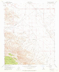
1953 Map of Shale Point
USGS Topo · Published 1964About this map
Twisselmann Ranch sits at the heart of this dryland landscape, marking a point of human settlement between the rugged Temblor Range and the expanding industrial infrastructure of the North Antelope Hills Oil Field. In the early 1950s, this area of Kern County was characterized by its reliance on dispersed water sources and mineral extraction. The map reveals a network of vital springs tucked into the higher elevations, including Alex Cook Spr, Napoleon Spr, and Cedar Spr. These water points contrast with the industrial activity signaled by Oil Tanks and several Test Wells scattered across the Antelope Plain. Topographically, the transition from the high ridges of the Shale Hills down to the Bitterwater Valley illustrates the drainage patterns of ephemeral streams like Bitterwater Creek and Packwood Cr, which shaped the ranching and resource-gathering efforts of the era.
Find a feature on this map
20 named features on this map. Tap any name to fly to it.
Don’t see what you’re looking for? This feature index may not catch every label — zoom into the map to look around manually.
Map Details
Editions of this 1953 Shale Point Map
3 editions found
Other maps of this area

1912 · McKittrick
USGS Topo · 1:125,000

1914 · Lost Hills
USGS Topo · 1:125,000

1914 · Cholame
USGS Topo · 1:125,000

1915 · Cholame
USGS Topo · 1:125,000

1917 · Cholame
USGS Topo · 1:125,000

1932 · Antelope Plain
USGS Topo · 1:31,680

1932 · La Panza
USGS Topo · 1:48,000

1935 · La Panza
USGS Topo · 1:62,500
1936 · Antelope Plain
USGS Topo · 1:31,680

1936 · La Panza
USGS Topo · 1:62,500