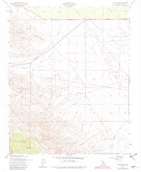
1953 Map of Shale Point
USGS Topo · Published 1982About this map
The Shale Hills and Temblor Range dominate this Kern County landscape, where the arid transition between high ground and the Antelope Plain is defined by ephemeral drainages and early industrial development. Industrial activity is concentrated at the North Antelope Hills Oil Field, marked by numerous oil tanks and a test well, indicating the region's mid-century reliance on petroleum extraction. Agriculture and ranching are represented by the Twisselmann Ranch and scattered water sources like Alex Cook Spr and Napoleon Spr, which were vital for survival in the dry Bitterwater Valley. The terrain is deeply etched by Bitterwater Creek and Devilwater Creek, while a quarry and several windmills signify the modest human footprint on these foothills before later developments altered the local character.
Find a feature on this map
20 named features on this map. Tap any name to fly to it.
Don’t see what you’re looking for? This feature index may not catch every label — zoom into the map to look around manually.
Map Details
Editions of this 1953 Shale Point Map
3 editions found
Other maps of this area

1912 · McKittrick
USGS Topo · 1:125,000

1914 · Lost Hills
USGS Topo · 1:125,000

1914 · Cholame
USGS Topo · 1:125,000

1915 · Cholame
USGS Topo · 1:125,000

1917 · Cholame
USGS Topo · 1:125,000

1932 · Antelope Plain
USGS Topo · 1:31,680

1932 · La Panza
USGS Topo · 1:48,000

1935 · La Panza
USGS Topo · 1:62,500
1936 · Antelope Plain
USGS Topo · 1:31,680

1936 · La Panza
USGS Topo · 1:62,500