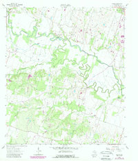
1963 Map of Sharp
USGS Topo · Published 1989About this map
The meanders of the Little River define this rural landscape in Milam County, Texas, as it appeared in the mid-20th century. The waterway is flanked by a complex system of oxbows and secondary channels, including the Cutoff Slough and Mumford Lake, illustrating the dynamic nature of this river valley. Small agrarian communities and family-named landmarks are scattered throughout the territory, from Buckholts in the north to the settlement of Sharp in the south. Local history is deeply embedded in the rural infrastructure, represented by numerous country churches like Friendship Ch and Liveoak Ch. A notable concentration of cemeteries, such as Bryant Station Cem and the McFarland Cem, provides a map of early settlement patterns and family heritage in the region. The map also records the location of the Bryant Station Bridge and Cummins Crossing, vital points of transit for a landscape shaped by its creeks and hollows.
Find a feature on this map
30 named features on this map. Tap any name to fly to it.
Don’t see what you’re looking for? This feature index may not catch every label — zoom into the map to look around manually.
Map Details
Editions of this 1963 Sharp Map
3 editions found
Other maps of this area

1885 · Taylor
USGS Topo · 1:125,000

1887 · Taylor
USGS Topo · 1:125,000

1894 · Taylor
USGS Topo · 1:125,000

1910 · Buckholts
USGS Topo · 1:24,000

1912 · Buckholts
USGS Topo · 1:31,680

1954 · Austin
USGS Topo · 1:250,000

1962 · Rockdale West
USGS Topo · 1:24,000
1962 · Pettibone
USGS Topo · 1:24,000
1963 · Sharp
USGS Topo · 1:24,000

1963 · Friendship
USGS Topo · 1:24,000