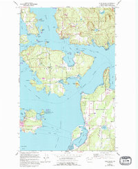
1973 Map of Shaw Island
USGS Topo · Published 1994About this map
Shaw Island serves as the central focus of this coastal study, illustrating the maritime and rural character of the San Juan archipelago in the early 1970s, with updates reflecting changes through the late 1980s. The island's geography is defined by its numerous inlets and points, including Blind Bay and Hicks Bay, while its social center is anchored by the Post Office and a local Cem. Transportation depends heavily on ferry routes traversing the Wasp Passage and Harney Channel, linking the island to neighboring Orcas and the larger settlement at Lopez.
Find a feature on this map
76 named features on this map. Tap any name to fly to it.
Don’t see what you’re looking for? This feature index may not catch every label — zoom into the map to look around manually.
Map Details
Editions of this 1973 Shaw Island Map
2 editions found
Other maps of this area

1943 · Richardson
USGS Topo · 1:62,500

1943 · Orcas Island
USGS Topo · 1:62,500

1954 · Waldron Island
USGS Topo · 1:24,000

1954 · Friday Harbor
USGS Topo · 1:24,000

1954 · False Bay
USGS Topo · 1:24,000

1957 · Richardson
USGS Topo · 1:62,500

1957 · Orcas Island
USGS Topo · 1:62,500

1957 · Victoria
USGS Topo · 1:250,000
1973 · Lopez Pass
USGS Topo · 1:24,000

1973 · Shaw Island
USGS Topo · 1:24,000