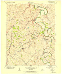
1954 Map of Shawhan
USGS Topo · Published 1955About this map
Shawhan serves as a central point in this mid-century survey of the Bluegrass region, where the Harrison Co Bourbon Co line divides a landscape defined by rolling agricultural land and winding waterways. The South Fork Licking River carves deep loops across the northern half of the map, passing the County Infirmary and the settlement of Lair. The rural infrastructure of the 1950s is highly visible, from the tracks of the Louisville and Nashville railroad to small community anchors like Mt Pleasant Ch and Mt Carmel Ch. Local history researchers will find a dense network of country roads including Russell Cave Road and Batterton Road, which connect older hamlets like Jacksonville and Broadwell. The convergence of Townsend Creek and Stoner Creek in the south highlights the importance of drainage and topography in shaping the area's development.
Find a feature on this map
33 named features on this map. Tap any name to fly to it.
Don’t see what you’re looking for? This feature index may not catch every label — zoom into the map to look around manually.
Map Details
Editions of this 1954 Shawhan Map
2 editions found
Other maps of this area

1927 · Lexington
USGS Topo · 1:48,000

1929 · Cynthiana
USGS Topo · 1:48,000

1929 · Lexington
USGS Topo · 1:62,500

1934 · Cynthiana
USGS Topo · 1:62,500

1952 · Paris East
USGS Topo · 1:24,000

1952 · Shady Nook
USGS Topo · 1:24,000

1953 · Millersburg
USGS Topo · 1:24,000

1953 · Breckinridge
USGS Topo · 1:24,000
1953 · Cynthiana
USGS Topo · 1:24,000
1954 · Leesburg
USGS Topo · 1:24,000