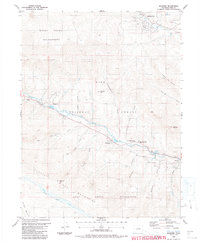
1987 Map of Shawnee
USGS Topo · Published 1987About this map
Shawnee and the neighboring settlements of Singleton and Weller sit nestled along the North Fork South Platte River during the late 1980s. This survey illustrates the vital corridor following the river and Highway 285, where educational hubs like Platte Canyon High School and Jesse B Fitzsimmons Middle School serve the local population. The map captures a transition between the valley floor and the high-elevation terrain of the Mount Evans Wilderness to the north and the Lost Creek Wilderness to the south.
Find a feature on this map
43 named features on this map. Tap any name to fly to it.
Don’t see what you’re looking for? This feature index may not catch every label — zoom into the map to look around manually.
Map Details
Editions of this 1987 Shawnee Map
2 editions found
Other maps of this area

1893 · Platte Canyon
USGS Topo · 1:125,000

1899 · West Denver
USGS Topo · 1:125,000

1903 · Georgetown
USGS Topo · 1:62,500

1905 · Georgetown
USGS Topo · 1:62,500

1945 · Bailey
USGS Topo · 1:24,000

1945 · Shawnee
USGS Topo · 1:24,000

1945 · Mount Logan
USGS Topo · 1:24,000

1948 · Mount Logan
USGS Topo · 1:24,000

1948 · Shawnee
USGS Topo · 1:24,000

1949 · Bailey
USGS Topo · 1:24,000