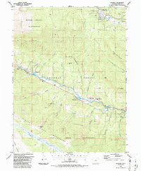
1987 Map of Shawnee
USGS Topo · Published 1987About this map
The North Fork South Platte River carves a central corridor through this mountain landscape, dictating the placement of settlements and transport routes. Along the river valley, the small community of Shawnee serves as a focal point, flanked by educational landmarks such as Platte Canyon High School and Jesse B Fitzsimmons Middle School. This 1980s survey reflects the established mountain corridor along U.S. 285, where smaller hamlets like Glenisle, Singleton, and Weller sit tucked against the canyon walls. Much of the surrounding territory is protected land, bracketed by the Mount Evans Wilderness to the north and the Lost Creek Wilderness to the south. The terrain is marked by numerous drainage gulches, including Slaughterhouse Gulch and Ben Tyler Gulch, while high points like Derringer Peak and Shawnee Peak rise above the Pike National Forest.
Find a feature on this map
45 named features on this map. Tap any name to fly to it.
Don’t see what you’re looking for? This feature index may not catch every label — zoom into the map to look around manually.
Map Details
Editions of this 1987 Shawnee Map
2 editions found
Other maps of this area

1893 · Platte Canyon
USGS Topo · 1:125,000

1899 · West Denver
USGS Topo · 1:125,000

1903 · Georgetown
USGS Topo · 1:62,500

1905 · Georgetown
USGS Topo · 1:62,500

1945 · Bailey
USGS Topo · 1:24,000

1945 · Shawnee
USGS Topo · 1:24,000

1945 · Mount Logan
USGS Topo · 1:24,000

1948 · Mount Logan
USGS Topo · 1:24,000

1948 · Shawnee
USGS Topo · 1:24,000

1949 · Bailey
USGS Topo · 1:24,000