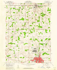
1960 Map of Shelby
USGS Topo · Published 1961About this map
The Wilkins Air Force Station occupies a significant footprint in the center of this 1960 survey, illustrating the Cold War era's military presence in rural Ohio. This landscape marks the intersection of three counties—Richland, Huron, and Crawford—where the historic Connecticut Western Reserve meets the Congress Lands. The southern portion is dominated by the industrial and residential core of Shelby, showing the New York Central and Baltimore and Ohio railroads converging near Central High Sch. In the more agricultural north, the village of Plymouth straddles the county line, while smaller rural nodes like Auburn Center and New Pittsburgh are connected by a grid of family-named routes such as Dinninger Road and Hazel Brush Road. Waterways like Marsh Run and Black Fork Mohican River provide natural drainage through the alternating patches of woodlots and cleared farmland.
Find a feature on this map
68 named features on this map. Tap any name to fly to it.
Don’t see what you’re looking for? This feature index may not catch every label — zoom into the map to look around manually.
Map Details
Editions of this 1960 Shelby Map
3 editions found
Other maps of this area

1915 · Norwalk
USGS Topo · 1:62,500

1915 · Siam
USGS Topo · 1:62,500

1915 · Bucyrus
USGS Topo · 1:62,500

1915 · Crestline
USGS Topo · 1:62,500

1943 · Bucyrus
USGS Topo · 1:62,500

1943 · Crestline
USGS Topo · 1:62,500

1944 · Norwalk
USGS Topo · 1:62,500

1950 · Marion
USGS Topo · 1:250,000

1956 · Toledo
USGS Topo · 1:250,000

1960 · North Robinson
USGS Topo · 1:24,000