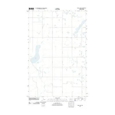
2011 Map of Shell Lake
USGS Topo · Published 2011About this map
Shell Lake dominates the western portion of this Mountrail County landscape, serving as a primary hydrologic focal point alongside Shell Creek. The terrain is defined by a sparse, grid-based road network characteristic of the North Dakota prairie, where section lines are traced by routes like 57th St NW and 68th Ave Nw. This 2011 survey, published by the U.S. Geological Survey, illustrates a modern rural environment where small kettle lakes and wetlands are scattered between the surveyed lines of 60th St Nw and 65th Ave Nw. The geography remains largely open and agricultural, with the lack of dense settlements highlighting the expansive nature of the High Plains at the start of the 21st century.
Find a feature on this map
16 named features on this map. Tap any name to fly to it.
Don’t see what you’re looking for? This feature index may not catch every label — zoom into the map to look around manually.
Map Details
Editions of this 2011 Shell Lake Map
This is the sole edition of this map. No revisions or reprints were ever made.
Other maps of this area

1953 · Williston
USGS Topo · 1:250,000

1954 · Minot
USGS Topo · 1:250,000

1957 · Williston
USGS Topo · 1:250,000

1958 · Minot
USGS Topo · 1:250,000

1980 · Minot
USGS Topo · 1:100,000
1980 · Plaza
USGS Topo · 1:24,000

1980 · Tagus
USGS Topo · 1:24,000
1981 · Epworth SE
USGS Topo · 1:24,000

1981 · Palermo
USGS Topo · 1:24,000
1981 · Shell Lake
USGS Topo · 1:24,000