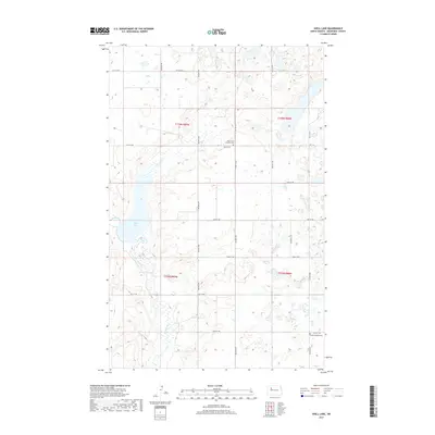
2017 Map of Shell Lake
USGS Topo · Published 2017About this map
Shell Lake and the winding course of Shell Creek dominate this prairie landscape in Mountrail County, where the topography is defined by numerous small wetlands and glacial depressions typical of the region. The map preserves the location of local spiritual and family anchors, specifically the Shell Creek Lutheran Cem situated along 55th St NW and the Trinity Lutheran Cem further south. This 2017 survey reflects a largely agricultural and rural character, organized by a strict section-line road grid including 68th Ave NW and 50th St NW. The drainage patterns of Shell Cr provide a natural counterpoint to the geometric regularity of the land survey system, illustrating how water and terrain have historically influenced the placement of homesteads and community sites across these townships.
Find a feature on this map
23 named features on this map. Tap any name to fly to it.
Don’t see what you’re looking for? This feature index may not catch every label — zoom into the map to look around manually.
Map Details
Editions of this 2017 Shell Lake Map
This is the sole edition of this map. No revisions or reprints were ever made.
Other maps of this area

1953 · Williston
USGS Topo · 1:250,000

1954 · Minot
USGS Topo · 1:250,000

1957 · Williston
USGS Topo · 1:250,000

1958 · Minot
USGS Topo · 1:250,000

1980 · Minot
USGS Topo · 1:100,000
1980 · Plaza
USGS Topo · 1:24,000

1980 · Tagus
USGS Topo · 1:24,000
1981 · Epworth SE
USGS Topo · 1:24,000

1981 · Palermo
USGS Topo · 1:24,000
1981 · Shell Lake
USGS Topo · 1:24,000