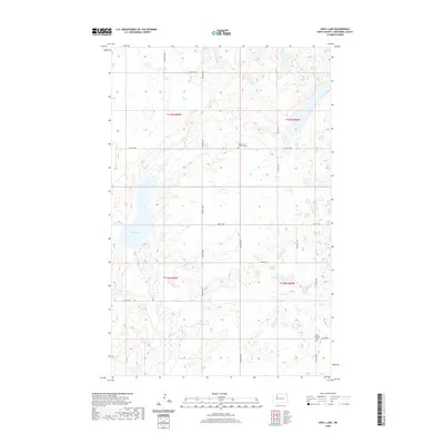
2020 Map of Shell Lake
USGS Topo · Published 2020About this map
Shell Lake and the winding course of Shell Creek anchor this landscape in Mountrail County. This 2020 digital survey illustrates the contemporary geography of the Missouri Plateau, where a high density of small wetlands and prairie potholes defines the local drainage patterns. The map is organized by the Public Land Survey System, showing the intersection of townships T154N and T155N, with a sparse network of section-line roads like 67th Ave NW and 55th St NW providing the primary access through the region. Cultural markers are largely confined to the community heritage found at Shell Creek Lutheran Cem and Trinity Lutheran Cem, which serve as quiet landmarks among the open fields and rolling hills of the High Plains.
Find a feature on this map
21 named features on this map. Tap any name to fly to it.
Don’t see what you’re looking for? This feature index may not catch every label — zoom into the map to look around manually.
Map Details
Editions of this 2020 Shell Lake Map
This is the sole edition of this map. No revisions or reprints were ever made.
Other maps of this area

1953 · Williston
USGS Topo · 1:250,000

1954 · Minot
USGS Topo · 1:250,000

1957 · Williston
USGS Topo · 1:250,000

1958 · Minot
USGS Topo · 1:250,000

1980 · Minot
USGS Topo · 1:100,000
1980 · Plaza
USGS Topo · 1:24,000

1980 · Tagus
USGS Topo · 1:24,000
1981 · Epworth SE
USGS Topo · 1:24,000

1981 · Palermo
USGS Topo · 1:24,000
1981 · Shell Lake
USGS Topo · 1:24,000