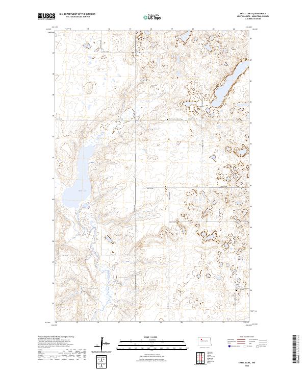
2024 Map of Shell Lake
USGS Topo · Published 2024About this map
Shell Lake National Wildlife Refuge anchors this northern plains landscape, a vital sanctuary for migratory birds and local wildlife in the Missouri Plateau region. The map details a prairie pothole environment where Shell Lake and the winding Shell Creek provide water sources amidst the undulating terrain. This 2024 survey documents a predominantly agricultural grid of section lines, but reveals the deeper roots of the community through its preserved religious sites. Genealogists and local historians can pinpoint the Shell Creek Lutheran Cem and Trinity Lutheran Cem, landmarks that suggest the area's early settlement history. Significant conservation efforts are further evidenced by the Mountrail County Waterfowl Production Area, which protects the wetlands and grasslands essential to the region's ecological health.
Find a feature on this map
23 named features on this map. Tap any name to fly to it.
Don’t see what you’re looking for? This feature index may not catch every label — zoom into the map to look around manually.
Map Details
Editions of this 2024 Shell Lake Map
This is the sole edition of this map. No revisions or reprints were ever made.
Other maps of this area

1953 · Williston
USGS Topo · 1:250,000

1954 · Minot
USGS Topo · 1:250,000

1957 · Williston
USGS Topo · 1:250,000

1958 · Minot
USGS Topo · 1:250,000

1980 · Minot
USGS Topo · 1:100,000
1980 · Plaza
USGS Topo · 1:24,000

1980 · Tagus
USGS Topo · 1:24,000
1981 · Epworth SE
USGS Topo · 1:24,000

1981 · Palermo
USGS Topo · 1:24,000
1981 · Shell Lake
USGS Topo · 1:24,000