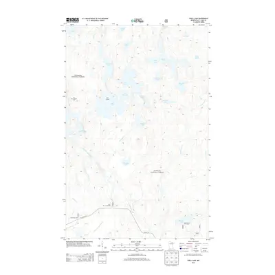
2013 Map of Shell Lake
USGS Topo · Published 2013About this map
Superior National Forest defines the landscape of this region, which is dominated by a complex network of glacial lakes and waterways in northern Minnesota. The Little Indian Sioux River meanders through the western portion of the map, passing the Sioux River Lookout Tower and providing drainage for a dense cluster of water bodies including Shell Lake, Lower Pauness Lake, and Heritage Lake. This wilderness area exhibits a distinct lack of permanent settlements, focused instead on recreational and forest management infrastructure. Public access points are localized along the southern margin near Co Hwy 116, where the Sioux River Campground and the Meander Lake Picnic Area serve as gateways to the interior. The presence of numerous smaller lakes such as Woksapiwi Lake and Agawato Lake highlights the intricate drainage patterns of the Boundary Waters vicinity.
Find a feature on this map
38 named features on this map. Tap any name to fly to it.
Don’t see what you’re looking for? This feature index may not catch every label — zoom into the map to look around manually.
Map Details
Editions of this 2013 Shell Lake Map
This is the sole edition of this map. No revisions or reprints were ever made.
Other maps of this area

1954 · International Falls
USGS Topo · 1:250,000

1957 · International Falls
USGS Topo · 1:250,000

1958 · International Falls
USGS Topo · 1:250,000
1963 · Coleman Island
USGS Topo · 1:24,000

1963 · Takucmich Lake
USGS Topo · 1:24,000

1963 · Snow Bay
USGS Topo · 1:24,000

1963 · Astrid Lake
USGS Topo · 1:24,000

1963 · Lake Jeanette
USGS Topo · 1:24,000
1963 · Lapond Lake
USGS Topo · 1:24,000
1963 · Shell Lake
USGS Topo · 1:24,000