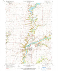
1971 Map of Sheridan
USGS Topo · Published 1991About this map
Sheridan sits prominently on the Fox River in this early 1970s survey, a period when the landscape balanced institutional land use with growing recreational development. To the south, the extensive campus of the Illinois Industrial School For Boys occupies a large bend in the river, while to the north, the winding Somonauk Creek feeds into the residential waterfront of Lake Holiday. The map provides a unique look at historical boundaries, clearly marking the Old Indian Treaty Boundary as it cuts across the township lines of Northville and Adams.
Find a feature on this map
33 named features on this map. Tap any name to fly to it.
Don’t see what you’re looking for? This feature index may not catch every label — zoom into the map to look around manually.
Map Details
Editions of this 1971 Sheridan Map
2 editions found
Other maps of this area

1892 · Marseilles
USGS Topo · 1:62,500

1892 · Ottawa
USGS Topo · 1:62,500

1915 · Ottawa
USGS Topo · 1:62,500

1916 · Marseilles
USGS Topo · 1:62,500

1940 · Marseilles
USGS Topo · 1:62,500

1946 · Ottawa
USGS Topo · 1:62,500

1948 · Sandwich
USGS Topo · 1:62,500

1950 · Sandwich
USGS Topo · 1:62,500

1951 · Earlville
USGS Topo · 1:62,500

1958 · Aurora
USGS Topo · 1:250,000