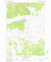
1965 Map of Sheridan Reservoir
USGS Topo · Published 1981About this map
Sheridan Reservoir sits at the heart of this high-altitude landscape, flanked by the prominent Sheridan Ridge to the south. This mid-1960s survey documents a network of water management and backcountry access within the Targhee National Forest, where the terrain is defined by the headwaters of Sheridan Creek and its many tributaries like Mud Creek and Taylor Creek. The map provides specific locations for water sources critical to the region's management, including Shotgun Well and Bishop Burn Well. Geodetic data across the Clark and Fremont County line reveals a primitive transportation network consisting largely of Jeep Trails and Pack Trails, emphasizing the area's use for forestry and recreation. The detailed topographic contouring captures the transition from the reservoir basin to the surrounding peaks and named landmarks like Bear Hole.
Find a feature on this map
22 named features on this map. Tap any name to fly to it.
Don’t see what you’re looking for? This feature index may not catch every label — zoom into the map to look around manually.
Map Details
Editions of this 1965 Sheridan Reservoir Map
3 editions found
Other maps of this area

1950 · Lower Red Rock Lake
USGS Topo · 1:62,500

1950 · Upper Red Rock Lake
USGS Topo · 1:62,500

1955 · Ashton
USGS Topo · 1:250,000

1958 · Ashton
USGS Topo · 1:250,000

1960 · Ashton
USGS Topo · 1:250,000
1965 · Icehouse Creek
USGS Topo · 1:24,000

1965 · Crystal Butte
USGS Topo · 1:24,000
1965 · Bishop Mountain
USGS Topo · 1:24,000

1965 · Sheridan Reservoir
USGS Topo · 1:24,000

1972 · Pine Butte
USGS Topo · 1:24,000