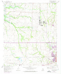
1958 Map of Sherman NW
USGS Topo · Published 1975About this map
The Hagerman National Wildlife Refuge anchors the northwest corner of this landscape, established as a sanctuary for migratory birds on the shores of Lake Texoma. This 1950s survey captures the mid-century expansion of Sherman, where residential blocks begin to push toward the edge of Sherman Field. The economic life of the area is mapped through a series of Oil Wells and the intersecting routes of the Missouri - Kansas - Texas and Texas and Pacific railroads. Community centers like Hagerman Ch and Friendship Ch provide important markers for genealogists, alongside local burial sites at Enterprise Cem and Kersey Cem. Notable landmarks include the Woodmen Circle Home and the Wakefield Sch, providing a look at the social infrastructure of Grayson County during this era of growth.
Find a feature on this map
22 named features on this map. Tap any name to fly to it.
Don’t see what you’re looking for? This feature index may not catch every label — zoom into the map to look around manually.
Map Details
Editions of this 1958 Sherman NW Map
3 editions found
Other maps of this area

1901 · Denison
USGS Topo · 1:125,000

1954 · Sherman
USGS Topo · 1:250,000

1957 · Denison Dam
USGS Topo · 1:24,000

1958 · Dorchester
USGS Topo · 1:24,000

1958 · Gordonville
USGS Topo · 1:62,500

1958 · Denison Dam
USGS Topo · 1:62,500

1958 · Sherman NW
USGS Topo · 1:24,000

1958 · Whitesboro
USGS Topo · 1:62,500

1958 · Sherman
USGS Topo · 1:250,000

1958 · Sherman
USGS Topo · 1:62,500