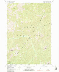
1963 Map of Sherman Peak
USGS Topo · Published 1991About this map
Frank Church River of No Return Wilderness and the surrounding Challis National Forest dominate this 1963 survey of Custer County. The landscape is defined by its deep drainage networks and high summits, notably Sherman Peak and Mayfield Peak. The complex hydrology of the Salmon River mountains is visible through the branching headwaters of Mayfield Creek, including its East Fork and West Fork. To the north, Mid Cottonwood Point stands above Cottonwood Creek, while several Springs and named drainages like Wick iup Creek and McKee Creek illustrate the untouched character of this backcountry area. The map records the primitive state of these highlands during the early 1960s, prior to any significant modern changes as confirmed by 1980 inspections.
Find a feature on this map
18 named features on this map. Tap any name to fly to it.
Don’t see what you’re looking for? This feature index may not catch every label — zoom into the map to look around manually.
Map Details
Editions of this 1963 Sherman Peak Map
3 editions found
Other maps of this area

1919 · Custer
USGS Topo · 1:125,000

1922 · Custer
USGS Topo · 1:125,000

1930 · Casto
USGS Topo · 1:125,000

1957 · Challis
USGS Topo · 1:250,000

1960 · Challis
USGS Topo · 1:250,000

1963 · Challis
USGS Topo · 1:250,000

1963 · Challis Creek Lakes
USGS Topo · 1:24,000

1963 · Custer
USGS Topo · 1:24,000

1963 · Casto
USGS Topo · 1:24,000

1963 · Rock Creek
USGS Topo · 1:24,000