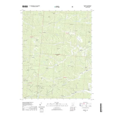
2019 Map of Sherritts
USGS Topo · Published 2019About this map
Wayne National Forest dominates this Lawrence County landscape, where the deeply dissected plateau of southern Ohio is carved by intricate drainage systems like Slab Fork Johns Creek and Symmes Creek. This survey details a rural region defined by its narrow hollows and high ridges, including Zoar Ridge and Tick Ridge. The map serves as a significant genealogical resource, preserving the locations of numerous family and church burial grounds such as Stewart Werner Cemetery, Slab Fork Church Cemetery, and the Joe Delawder Cemetery north of McClure Lake. The settlement pattern follows the creek beds and ridge lines, with small communities like Sherritts and Forest Ridge connected by a network of forest roads and recreational paths, including the Vesuvius Main Loop and the Backpack Trail. Near the southern boundary, Nelson Bridge crosses Symmes Creek, marking a long-standing transit point in the local topography.
Find a feature on this map
110 named features on this map. Tap any name to fly to it.
Don’t see what you’re looking for? This feature index may not catch every label — zoom into the map to look around manually.
Map Details
Editions of this 2019 Sherritts Map
This is the sole edition of this map. No revisions or reprints were ever made.
Other maps of this area

1898 · Ironton
USGS Topo · 1:62,500

1900 · Ironton
USGS Topo · 1:62,500

1906 · Bidwell
USGS Topo · 1:62,500

1906 · Athalia
USGS Topo · 1:62,500

1908 · Bidwell
USGS Topo · 1:62,500

1908 · Athalia
USGS Topo · 1:62,500

1912 · Oak Hill
USGS Topo · 1:62,500
1953 · Ironton
USGS Topo · 1:24,000

1957 · Huntington
USGS Topo · 1:250,000
1958 · Ironton
USGS Topo · 1:24,000