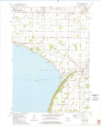
1974 Map of Sherwood
USGS Topo · Published 1978About this map
The northeastern shoreline of Lake Winnebago defines the character of this mid-1970s landscape, where residential expansion from Appleton meets the rural townships of Harrison and Buchanan. The prominent elevation of High Cliff serves as the focal point for High Cliff State Park, a site of both natural interest and industrial history evidenced by the Limekiln Ruins and several active quarries.
Find a feature on this map
48 named features on this map. Tap any name to fly to it.
Don’t see what you’re looking for? This feature index may not catch every label — zoom into the map to look around manually.
Map Details
Editions of this 1974 Sherwood Map
2 editions found
Other maps of this area

1911 · Neenah
USGS Topo · 1:62,500

1954 · De Pere
USGS Topo · 1:62,500

1954 · Chilton
USGS Topo · 1:62,500

1955 · Neenah
USGS Topo · 1:62,500

1955 · Appleton
USGS Topo · 1:24,000

1955 · Appleton
USGS Topo · 1:62,500

1955 · Neenah
USGS Topo · 1:24,000

1955 · Green Bay
USGS Topo · 1:250,000

1974 · Hilbert
USGS Topo · 1:24,000
1974 · Chilton
USGS Topo · 1:24,000