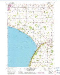
1974 Map of Sherwood
USGS Topo · Published 1984About this map
Lake Winnebago's northeastern shore dominates this mid-1970s landscape, where the dramatic elevation of High Cliff creates a sharp natural boundary between the water and the agricultural uplands. The era’s industrial footprint is visible through the Industrial Waste Ponds and the Chicago Milwaukee St Paul and Pacific railroad line cutting through the terrain. A clear transition toward recreation and modern development is evident in the presence of High Cliff State Park, which preserves the historic Limekiln Ruins and the High Cliff Country Club. The map provides a detailed view of shifting land use as the urban edges of Appleton expand, reaching toward smaller communities like Darboy and Sherwood. Local history is anchored by sites such as Sacred Heart Cem and the Wisconsin International Raceway, illustrating the varied cultural and economic layers of Calumet and Outagamie counties during this period.
Find a feature on this map
41 named features on this map. Tap any name to fly to it.
Don’t see what you’re looking for? This feature index may not catch every label — zoom into the map to look around manually.
Map Details
Editions of this 1974 Sherwood Map
2 editions found
Other maps of this area

1911 · Neenah
USGS Topo · 1:62,500

1954 · De Pere
USGS Topo · 1:62,500

1954 · Chilton
USGS Topo · 1:62,500

1955 · Neenah
USGS Topo · 1:62,500

1955 · Appleton
USGS Topo · 1:24,000

1955 · Appleton
USGS Topo · 1:62,500

1955 · Neenah
USGS Topo · 1:24,000

1955 · Green Bay
USGS Topo · 1:250,000

1974 · Hilbert
USGS Topo · 1:24,000
1974 · Chilton
USGS Topo · 1:24,000