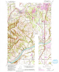
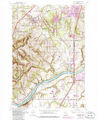
1961 Map of Sherwood
USGS Topo · Published 1991About this map
Parrett Mountain rises dramatically above the fertile agricultural expanses of French Prairie and the banks of the Willamette River, defining the rural character of this landscape in the early 1960s. The region is marked by a network of established family farms and small settlements, including Sherwood and Wilsonville, which were then transitioning toward more modern infrastructure as seen in the development of the Baldock Freeway. Local history and genealogy are anchored by landmarks like Pleasant Hill Cem and Butteville Cem, while the Dammasch State Hospital stands as a significant institutional presence near Mulloy. The map illustrates the vital intersection of rail and river commerce, with the Southern Pacific line crossing through Tonquin and Sherwood, providing a clear record of the area's logistical and social layout before the suburban growth that would eventually transform the corridor between Tualatin and Wilsonville.
Find a feature on this map
57 named features on this map. Tap any name to fly to it.
Don’t see what you’re looking for? This feature index may not catch every label — zoom into the map to look around manually.
Map Details
Editions of this 1961 Sherwood Map
5 editions found
Other maps of this area

1914 · Oregon City
USGS Topo · 1:62,500

1916 · Tualatin
USGS Topo · 1:62,500

1923 · Mount Angel
USGS Topo · 1:62,500

1939 · Molalla
USGS Topo · 1:62,500

1939 · Oregon City
USGS Topo · 1:62,500

1939 · Tualatin
USGS Topo · 1:62,500

1940 · Tualatin
USGS Topo · 1:62,500

1940 · Molalla
USGS Topo · 1:62,500

1940 · Mount Angel
USGS Topo · 1:62,500

1941 · Oregon City
USGS Topo · 1:62,500