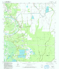
1993 Map of Shiloh
USGS Topo · Published 1994About this map
Moss Bluff and Swinney Bluff rise above the low-lying wetlands of the Trinity River delta, defining a landscape shaped by water and industry in the early 1990s. The settlement of Shiloh sits at a critical junction of creek systems and local roadways, surrounded by a high density of family and community burial grounds, including Pine Grove Cem, Norris Cem, and Worthy Cem. This concentration of cemeteries provides significant evidence of established rural lineages along the river's edge.
Find a feature on this map
50 named features on this map. Tap any name to fly to it.
Don’t see what you’re looking for? This feature index may not catch every label — zoom into the map to look around manually.
Map Details
Editions of this 1993 Shiloh Map
This is the sole edition of this map. No revisions or reprints were ever made.
Other maps of this area

1942 · Anahuac
USGS Topo · 1:24,000

1943 · Whites Bayou
USGS Topo · 1:24,000

1943 · Liberty
USGS Topo · 1:125,000

1950 · Houston
USGS Topo · 1:250,000

1954 · Beaumont
USGS Topo · 1:250,000

1955 · Daisetta
USGS Topo · 1:62,500

1955 · Liberty
USGS Topo · 1:62,500

1956 · Houston
USGS Topo · 1:250,000

1957 · Beaumont
USGS Topo · 1:250,000
1961 · Anahuac
USGS Topo · 1:24,000