
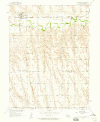
2017 Map of Shippee
USGS Topo · Published 2017About this map
Shippee sits at the heart of this landscape where the high plains of Southwest Nebraska meet the Kansas border. This 2017 survey documents the rural character of Red Willow County, defined by a network of sectional roads and natural drainages. The terrain is deeply carved by watercourses including Beaver Cr, Johnson Cr, and Wildcat Cr, which dictate the local topography and the winding paths of smaller routes like Dr 706.
Find a feature on this map
26 named features on this map. Tap any name to fly to it.
Don’t see what you’re looking for? This feature index may not catch every label — zoom into the map to look around manually.
Map Details
Editions of this 2017 Shippee Map
This is the sole edition of this map. No revisions or reprints were ever made.
Other maps of this area

1951 · Norcatur
USGS Topo · 1:62,500

1951 · Kanona
USGS Topo · 1:62,500

1954 · McCook
USGS Topo · 1:250,000

1954 · Goodland
USGS Topo · 1:250,000

1956 · Goodland
USGS Topo · 1:250,000

1957 · McCook
USGS Topo · 1:250,000

1957 · Goodland
USGS Topo · 1:250,000

1957 · Shippee
USGS Topo · 1:24,000
1957 · Wilsonville
USGS Topo · 1:24,000

1957 · Lebanon
USGS Topo · 1:24,000