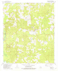
1981 Map of Shongaloo
USGS Topo · Published 1981About this map
The Shongaloo Oil and Gas Field and its surrounding extraction sites dominate this northwest Louisiana landscape, illustrating a late-twentieth-century economy built on petroleum and timber. The map documents two distinct centers of local life: the primary settlement of Shongaloo and the nearby Old Shongaloo, which remains anchored by the Old Shongaloo Cem. To the southwest, the Shongaloo Lookout Tower provides a vertical landmark near numerous Gravel Pits, while Bayou Dorcheat meanders through the bottomlands. Genealogy researchers will find several well-established country churches and family-named burial grounds, including Haynes Cem, Hudson Cem, and Saints Rest Ch. The network of roads and pipelines connecting the Haynesville Oil and Gas Field to the Cotton Valley Oil and Gas Field reflects the heavy industrial footprint etched into the wooded terrain and creek valleys.
Find a feature on this map
36 named features on this map. Tap any name to fly to it.
Don’t see what you’re looking for? This feature index may not catch every label — zoom into the map to look around manually.
Map Details
Editions of this 1981 Shongaloo Map
This is the sole edition of this map. No revisions or reprints were ever made.
Other maps of this area

1922 · Sarepta
USGS Topo · 1:62,500

1924 · Sarepta
USGS Topo · 1:62,500

1952 · Homer
USGS Topo · 1:62,500

1953 · El Dorado
USGS Topo · 1:250,000

1955 · Shreveport
USGS Topo · 1:250,000

1956 · Shreveport
USGS Topo · 1:250,000

1956 · Sarepta
USGS Topo · 1:62,500

1957 · El Dorado
USGS Topo · 1:250,000

1958 · El Dorado
USGS Topo · 1:250,000

1960 · El Dorado
USGS Topo · 1:250,000