
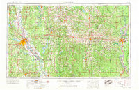
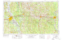
1955 Map of Shreveport
USGS Topo · Published 1955This historical map portrays the area of Shreveport in 1955, primarily covering Caddo Parish as well as portions of Lincoln Parish, Jackson Parish, Claiborne Parish, Winn Parish, Bienville Parish, Natchitoches Parish, Webster Parish, Ouachita Parish, Caldwell Parish, Bossier Parish, De Soto Parish, Morehouse Parish, Red River Parish, Union Parish, and Richland Parish. Featuring a scale of 1:250000, this map provides a highly detailed snapshot of the terrain, roads, buildings, counties, and historical landmarks in the Shreveport region at the time. Published in 1955, it is one of 3 known editions of this map due to revisions or reprints.
Find a feature on this map
184 named features on this map. Tap any name to fly to it.
Don’t see what you’re looking for? This feature index may not catch every label — zoom into the map to look around manually.
Map Details
Editions of this 1955 Shreveport Map
3 editions found
Historical Maps of Meadow Creek Estates Through Time
3 maps found

