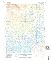
1955 Map of Shungnak D-5
USGS Topo · Published 1974About this map
The Waring Mountains dominate the northern landscape of this interior Alaska territory, where the topography shifts abruptly from high ridgelines to a complex, water-logged lowland. Surveyed in the mid-1950s, the map reveals a wilderness defined by its intricate hydrology. The Kugarak River winds through the southern half, surrounded by a dense network of unnamed ponds and wetlands that suggest a seasonal and shifting terrain. Notable water bodies such as Egaupak Lake and drainage systems like Nakoretlik Creek and Kerchurak Creek provide the primary geographic anchors in an area devoid of roads or permanent settlements. Geodetic markers, including Vabm 2702 Waring and Vabm 557 Wood, indicate the strategic points used by the Geological Survey to triangulate this remote expanse, offering precise elevation data for summits such as Vabm 271 Sand.
Find a feature on this map
9 named features on this map. Tap any name to fly to it.
Don’t see what you’re looking for? This feature index may not catch every label — zoom into the map to look around manually.
Map Details
Editions of this 1955 Shungnak D-5 Map
3 editions found
Other maps of this area

1951 · Shungnak
USGS Topo · 1:250,000

1951 · Ambler River
USGS Topo · 1:250,000

1955 · Shungnak
USGS Topo · 1:250,000

1955 · Ambler River A-4
USGS Topo · 1:63,360

1955 · Ambler River A-6
USGS Topo · 1:63,360

1955 · Shungnak D-4
USGS Topo · 1:63,360

1955 · Shungnak D-6
USGS Topo · 1:63,360

1955 · Shungnak D-5
USGS Topo · 1:63,360

1955 · Ambler River A-5
USGS Topo · 1:63,360

1956 · Ambler River
USGS Topo · 1:250,000