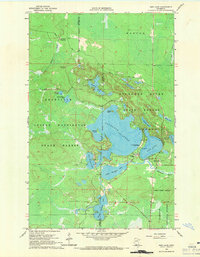
1964 Map of Side Lake
USGS Topo · Published 1971About this map
Sturgeon Lake and Side Lake anchor this 1964 survey, where the boundaries of Itasca and St Louis counties meet. The landscape is defined by the intersection of several managed wilderness areas, including the George Washington State Forest, Sturgeon River State Forest, and the western edge of the Superior National Forest. This era shows a dedicated recreational corridor emerging around McCarthy Beach State Park, featuring the Sturgeon Lake Mission and the Chapel of the Pines. Beyond the water, the terrain is marked by essential local landmarks like the Lookout Tower and a series of gravel pits and sandpits, highlighting the practical needs of rural infrastructure. The interconnected waters of Little Sturgeon Lake and West Sturgeon Lake reveal a complex drainage system fed by Snake Brook and Stony Brook.
Find a feature on this map
39 named features on this map. Tap any name to fly to it.
Don’t see what you’re looking for? This feature index may not catch every label — zoom into the map to look around manually.
Map Details
Editions of this 1964 Side Lake Map
3 editions found
Other maps of this area

1954 · Hibbing
USGS Topo · 1:250,000

1955 · Dewey Lake NW
USGS Topo · 1:24,000

1955 · Dewey Lake
USGS Topo · 1:24,000

1957 · Hibbing
USGS Topo · 1:250,000

1958 · Hibbing
USGS Topo · 1:250,000

1964 · Hibbing
USGS Topo · 1:250,000

1964 · Side Lake
USGS Topo · 1:24,000
1964 · Stingy Lake
USGS Topo · 1:24,000
1964 · Meadow Brook
USGS Topo · 1:24,000

1964 · Sherry Lake
USGS Topo · 1:24,000