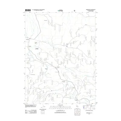
2012 Map of Sierraville
USGS Topo · Published 2012About this map
Sierraville and the neighboring settlement of Randolph anchor this eastern Sierra County landscape, situated where the valley floor meets the rising timber of the Tahoe National Forest. The geography is defined by a dense network of mountain drainage, with Cold Stream, Cottonwood Cr, and Onion Cr carving deep paths through Dark Canyon and Rice Canyon. The map reveals a transition from the agricultural and residential pockets near Canyon Ranch to high-elevation points like Treasure Mountain and Harding Point. Public recreation and early aviation are central to the area's character, evidenced by the Sierraville Dearwater Airport and the geothermal waters of Campbell Hot Springs. Modern access follows historical corridors, with Treasure Mountain Rd and Verdi Grade Rd threading through the canyons toward Little Truckee Summit and the Little Truckee River.
Find a feature on this map
29 named features on this map. Tap any name to fly to it.
Don’t see what you’re looking for? This feature index may not catch every label — zoom into the map to look around manually.
Map Details
Editions of this 2012 Sierraville Map
This is the sole edition of this map. No revisions or reprints were ever made.
Other maps of this area

1890 · Sierraville
USGS Topo · 1:125,000

1891 · Truckee
USGS Topo · 1:125,000

1892 · Sierraville
USGS Topo · 1:125,000

1893 · Truckee
USGS Topo · 1:125,000

1894 · Sierraville
USGS Topo · 1:125,000

1895 · Truckee
USGS Topo · 1:125,000

1932 · Truckee
USGS Topo · 1:96,000

1940 · Truckee
USGS Topo · 1:125,000

1955 · Loyalton
USGS Topo · 1:62,500
1955 · Donner Pass
USGS Topo · 1:62,500