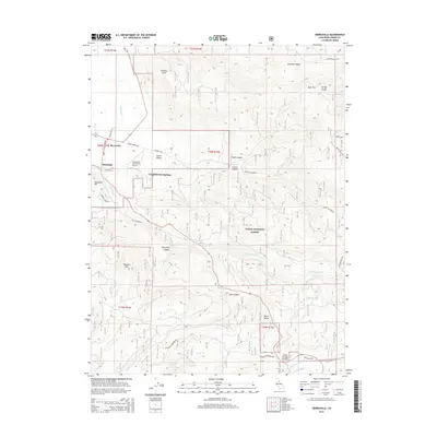
2015 Map of Sierraville
USGS Topo · Published 2015About this map
The high mountain valley of Sierra Valley serves as the focal point for this 2015 survey, where the small communities of Sierraville and Randolph sit at the intersection of early mountain thoroughfares. The landscape transitions from the flat valley floor to the steep, timbered slopes of the Tahoe National Forest, a terrain marked by deep drainages like Lemon Canyon and Rice Canyon. Historical routes and modern infrastructure coexist here, as seen with the Sierraville Dearwater Airport positioned near the legendary thermal waters of Campbell Hot Springs. The southern portion of the map is dominated by significant elevations and water systems, including the Little Truckee River and the high point at Treasure Mtn. Local transport is defined by rugged corridors like Henness Pass Rd and Old Truckee Rd, which have historically connected these isolated Sierra Nevada settlements to larger trade routes.
Find a feature on this map
45 named features on this map. Tap any name to fly to it.
Don’t see what you’re looking for? This feature index may not catch every label — zoom into the map to look around manually.
Map Details
Editions of this 2015 Sierraville Map
This is the sole edition of this map. No revisions or reprints were ever made.
Other maps of this area

1890 · Sierraville
USGS Topo · 1:125,000

1891 · Truckee
USGS Topo · 1:125,000

1892 · Sierraville
USGS Topo · 1:125,000

1893 · Truckee
USGS Topo · 1:125,000

1894 · Sierraville
USGS Topo · 1:125,000

1895 · Truckee
USGS Topo · 1:125,000

1932 · Truckee
USGS Topo · 1:96,000

1940 · Truckee
USGS Topo · 1:125,000

1955 · Loyalton
USGS Topo · 1:62,500
1955 · Donner Pass
USGS Topo · 1:62,500