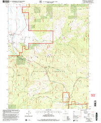
2000 Map of Sierraville
USGS Topo · Published 2003About this map
Sierraville and the neighboring settlement of Randolph anchor the southeastern corner of the Sierra Valley, where the valley floor meets the high timber of the Tahoe National Forest. This 2000 revision shows a landscape where historic transit routes and modern recreation intersect, highlighted by the Yuba Donner Scenic Byway and the historic Henness Pass Road. The presence of the Sierraville Ranger Station and the Sierra Dearwater Airport underscores the area's role as a regional hub for forest management and local aviation.
Find a feature on this map
44 named features on this map. Tap any name to fly to it.
Don’t see what you’re looking for? This feature index may not catch every label — zoom into the map to look around manually.
Map Details
Editions of this 2000 Sierraville Map
This is the sole edition of this map. No revisions or reprints were ever made.
Other maps of this area

1890 · Sierraville
USGS Topo · 1:125,000

1891 · Truckee
USGS Topo · 1:125,000

1892 · Sierraville
USGS Topo · 1:125,000

1893 · Truckee
USGS Topo · 1:125,000

1894 · Sierraville
USGS Topo · 1:125,000

1895 · Truckee
USGS Topo · 1:125,000

1932 · Truckee
USGS Topo · 1:96,000

1940 · Truckee
USGS Topo · 1:125,000

1955 · Loyalton
USGS Topo · 1:62,500
1955 · Donner Pass
USGS Topo · 1:62,500