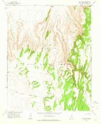
1962 Map of Silent Butte
USGS Topo · Published 1963About this map
Nellis Air Force Range and the northern edge of the Nevada Test Site dominate this landscape of the early 1960s, mapped in cooperation with the Atomic Energy Commission. The topography is defined by the massive volcanic structure of Basalt Ridge, which overlooks the deep incisions of Silent Canyon and South Silent Canyon. This high-desert terrain reaches a prominent peak at Silent Butte and the surveying station at VABM Silent 6956. Beyond the major geological formations, the map records a sparse network of communications consisting primarily of a Jeep Trail and various unmarked footpaths. To the southwest, the drainage of East Thirsty Canyon cuts through the volcanic plateau, illustrating the arid, erosional character of this restricted military research area.
Find a feature on this map
10 named features on this map. Tap any name to fly to it.
Don’t see what you’re looking for? This feature index may not catch every label — zoom into the map to look around manually.
Map Details
Editions of this 1962 Silent Butte Map
2 editions found
Other maps of this area

1908 · Kawich
USGS Topo · 1:250,000

1942 · Tolicha Peak
USGS Topo · 1:125,000

1942 · Wheelbarrow Peak
USGS Topo · 1:125,000

1952 · Timber Mountain
USGS Topo · 1:62,500

1952 · Silent Canyon
USGS Topo · 1:62,500
1952 · Black Mtn
USGS Topo · 1:62,500

1954 · Goldfield
USGS Topo · 1:250,000

1955 · Goldfield
USGS Topo · 1:250,000

1958 · Goldfield
USGS Topo · 1:250,000
1961 · Ammonia Tanks
USGS Topo · 1:24,000