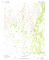
1962 Map of Silent Butte
USGS Topo · Published 1975About this map
Nellis Air Force Range and the northern reaches of the Nevada Test Site dominate this mid-century topographic survey, produced in cooperation with the Atomic Energy Commission. The landscape is defined by stark volcanic and erosional forms, most notably the prominent Basalt Ridge which runs north toward Silent Butte. The drainage patterns here are complex, featuring the deeply incised Silent Canyon and its tributary, South Silent Canyon, alongside the headwaters of East Thirsty Canyon. This area represents a restricted military and scientific corridor during the height of the Cold War, where travel was limited to primitive Jeep Trails and survey markers like Vabm Silent. The absence of civilian settlements reflects the region's specialized use for defense and nuclear research during the early 1960s.
Find a feature on this map
11 named features on this map. Tap any name to fly to it.
Don’t see what you’re looking for? This feature index may not catch every label — zoom into the map to look around manually.
Map Details
Editions of this 1962 Silent Butte Map
2 editions found
Other maps of this area

1908 · Kawich
USGS Topo · 1:250,000

1942 · Tolicha Peak
USGS Topo · 1:125,000

1942 · Wheelbarrow Peak
USGS Topo · 1:125,000

1952 · Timber Mountain
USGS Topo · 1:62,500

1952 · Silent Canyon
USGS Topo · 1:62,500
1952 · Black Mtn
USGS Topo · 1:62,500

1954 · Goldfield
USGS Topo · 1:250,000

1955 · Goldfield
USGS Topo · 1:250,000

1958 · Goldfield
USGS Topo · 1:250,000
1961 · Ammonia Tanks
USGS Topo · 1:24,000