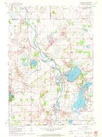
1960 Map of Silver Lake
USGS Topo · Published 1972About this map
The Fox River meanders through Kenosha County, anchoring a landscape of glacial lakes and mid-century recreational development. During the early 1960s, this region was defined by its water-oriented settlements and the shifting infrastructure of the Cold War era. To the north, the massive footprint of the Richard Bong Air Force Base (Abandoned) stands as a major landmark of military planning. The map captures established lakeside communities such as Silver Lake, Camp Lake, and Twin Lakes, where residential grids began to cluster near the shorelines of Center Lake and Marie Lake.
Find a feature on this map
44 named features on this map. Tap any name to fly to it.
Don’t see what you’re looking for? This feature index may not catch every label — zoom into the map to look around manually.
Map Details
Editions of this 1960 Silver Lake Map
3 editions found
Other maps of this area

1893 · Silver Lake
USGS Topo · 1:62,500

1893 · Geneva
USGS Topo · 1:62,500

1904 · Lake Geneva
USGS Topo · 1:62,500

1906 · Silver Lake
USGS Topo · 1:62,500

1906 · Lake Geneva
USGS Topo · 1:62,500

1920 · Grays Lake
USGS Topo · 1:62,500

1923 · Grays Lake
USGS Topo · 1:62,500

1926 · Mc Henry
USGS Topo · 1:62,500

1944 · McHenry
USGS Topo · 1:62,500

1954 · Rockford
USGS Topo · 1:250,000