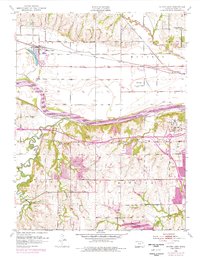
1952 Map of Silver Lake
USGS Topo · Published 1976About this map
Silver Lake and its namesake town define the northwestern corner of this Kansas landscape, where the Union Pacific railroad tracks parallel the north bank of the Kansas River. The mid-century topography reveals a transition from the river-bottom floodplains near Kiro and Menoken to the high ground of Hickory Knob and the rugged drainage basins of Mission Creek and Blacksmith Creek. Revisions from the 1970s show the westward expansion of Topeka and the development of Sherwood Lake, highlighting the encroachment of urban life into the surrounding townships of Mission and Dover. Infrastructure like the Allen Airpark, several radio towers for Radio Station (WIBW), and the Golden Rule Sch point to a community balancing agricultural roots with modern communication and transportation needs.
Find a feature on this map
30 named features on this map. Tap any name to fly to it.
Don’t see what you’re looking for? This feature index may not catch every label — zoom into the map to look around manually.
Map Details
Editions of this 1952 Silver Lake Map
4 editions found

Other maps of this area

1889 · Burlingame
USGS Topo · 1:125,000

1889 · Topeka
USGS Topo · 1:125,000

1894 · Burlingame
USGS Topo · 1:125,000

1894 · Topeka
USGS Topo · 1:125,000

1947 · Lawrence
USGS Topo · 1:250,000

1950 · Kansas City
USGS Topo · 1:250,000

1950 · Lawrence
USGS Topo · 1:250,000

1950 · Topeka
USGS Topo · 1:24,000

1951 · Topeka
USGS Topo · 1:24,000

1952 · Auburn
USGS Topo · 1:24,000