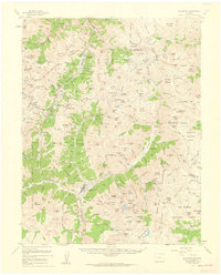
1955 Map of Silverton
USGS Topo · Published 1960About this map
Silverton serves as the industrial and social anchor of this high-altitude landscape, where the Denver and Rio Grande Western Railroad terminates near the banks of the Animas River. The 1950s era of mining is captured in extreme detail, showing a network of heavy industry concentrated along Cement Creek and the narrow gulches. Large-scale operations like the Mayflower Mill and the Sunnyside Mine define the economic life of the San Juan Mountains, while smaller claims such as the Old Hundred Mine and Pride of the West Mine pepper the slopes of King Solomon Mountain. Beyond the town site, the Million Dollar Highway (U S Highway 550) winds through the treacherous terrain toward Ironton, passing the St Germain Foundation and the remains of settlements like Chattanooga. This map provides a meticulous record of the relationship between industrial extraction and the difficult topography of the San Juan National Forest.
Find a feature on this map
225 named features on this map. Tap any name to fly to it.
Don’t see what you’re looking for? This feature index may not catch every label — zoom into the map to look around manually.
Map Details
Editions of this 1955 Silverton Map
3 editions found
Other maps of this area

1897 · Telluride
USGS Topo · 1:62,500

1897 · Silverton
USGS Topo · 1:62,500

1898 · Engineer Mountain
USGS Topo · 1:62,500

1900 · Engineer Mountain
USGS Topo · 1:62,500

1900 · Needle Mountains
USGS Topo · 1:62,500

1901 · Silverton
USGS Topo · 1:62,500

1902 · Needle Mountains
USGS Topo · 1:62,500

1902 · Silverton
USGS Topo · 1:62,500

1902 · Ouray
USGS Topo · 1:62,500

1903 · Lake City
USGS Topo · 1:62,500